
展位预订:021-3114 8748
参观/媒体联系:13601815988
QQ:2463282767
邮箱:artsexpo@sgexpo.cn
文章标题:
Extreme rainfall induced risk mapping for metro transit systems: Shanghai metro network as a case
文章作者(*为通讯):
1. Dongming Zhang 1,3,*
2. Hao Bai 1,3
3. Canzheng Zheng 5
4. Hongwei Huang 1,3
5. Bilal M. Ayyub 2,3,4
6. Wenjun Cao 6
作者单位:
1.Key Laboratory of Geotechnical and Underground Engineering of Minister of Education and Department of Geotechnical Engineering, Tongii University, Shanghai 200092, China
2.Center for Technology and Systems Management, Department of Civil and Environmental Engineering, University of Maryland, College Park, MD,20742, USA
3.International Joint Research Center for Resilient Infrastructure, Tongji University, China
4.Applied Economics Office, National Institute of Standards and Technology, Department of Commerce, USA
5.Jinan Rail Transit Group Co., Ltd, Jinan, China
6.Department of Civil Engineering, the University of Hong Kong, Hong Kong, China
关键词:
Risk assessment; Metro flooding; Extreme rainfall; Multi-layer network; Resilience.
原文链接:
https://doi.org/10.1016/j.ress.2025.111234
02 / 文章摘要
近年来,气候变迁引发的洪涝风险已对超大型城市地铁网络的安全可靠性构成重大威胁。高度网络化的地铁系统会加速风险传播,且受网络拓扑结构所定义的连通性影响,单节点事故的波及范围将呈现非线性放大效应。本研究提出融合极端降雨模拟与网络损失分析的风险评估框架:采用面折减系数(ARF)和水土保持局径流曲线数(SCS-CN)模型模拟降雨致涝过程,结合区分车站与线路拓扑关系的多层网络分析法。以上海地铁为例,研究揭示其洪灾风险服从指数分布规律——近50%的极端降雨事件仅造成低于5%的网络损失,而不足5%的事件会导致超50%的网络损失。当降雨中心位于站点密集、连接关系复杂的城市核心区,或当强降雨强度及空间分布不确定性增加时,地铁网络将面临更高风险。
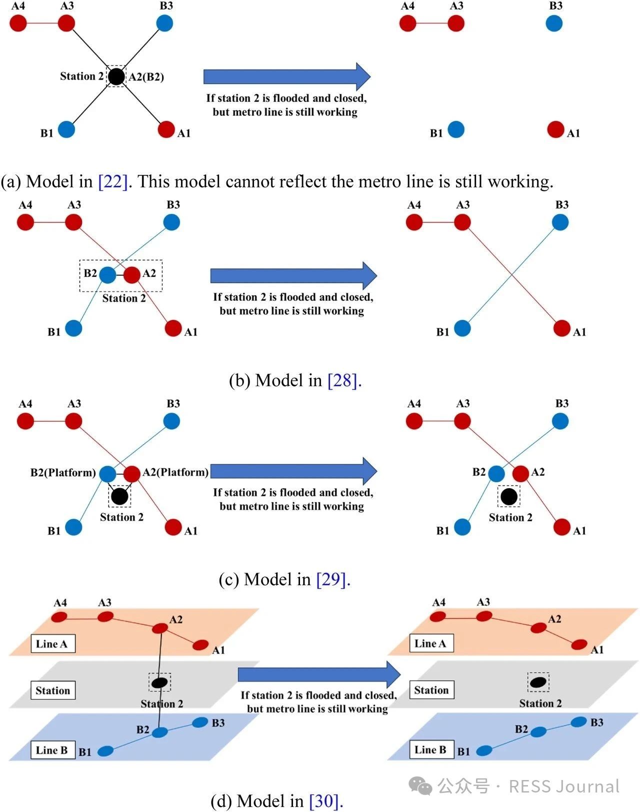
图1. 不同地铁网络模型对比

图2. 多层网络建模流程图
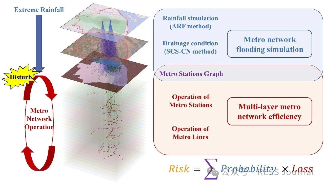
图3. 极端降雨下多层地铁网络风险评估框架
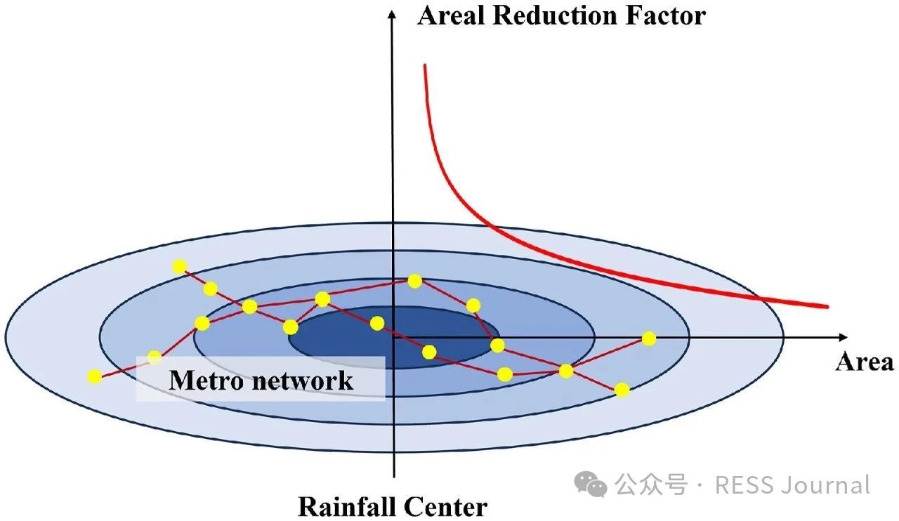
图4. 结合地铁网络的面折减系数曲线
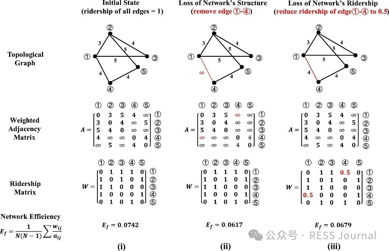
图5. 网络性能损失状态(i) 网络初始状态 (ii) 网络结构损失 (iii) 网络流损失
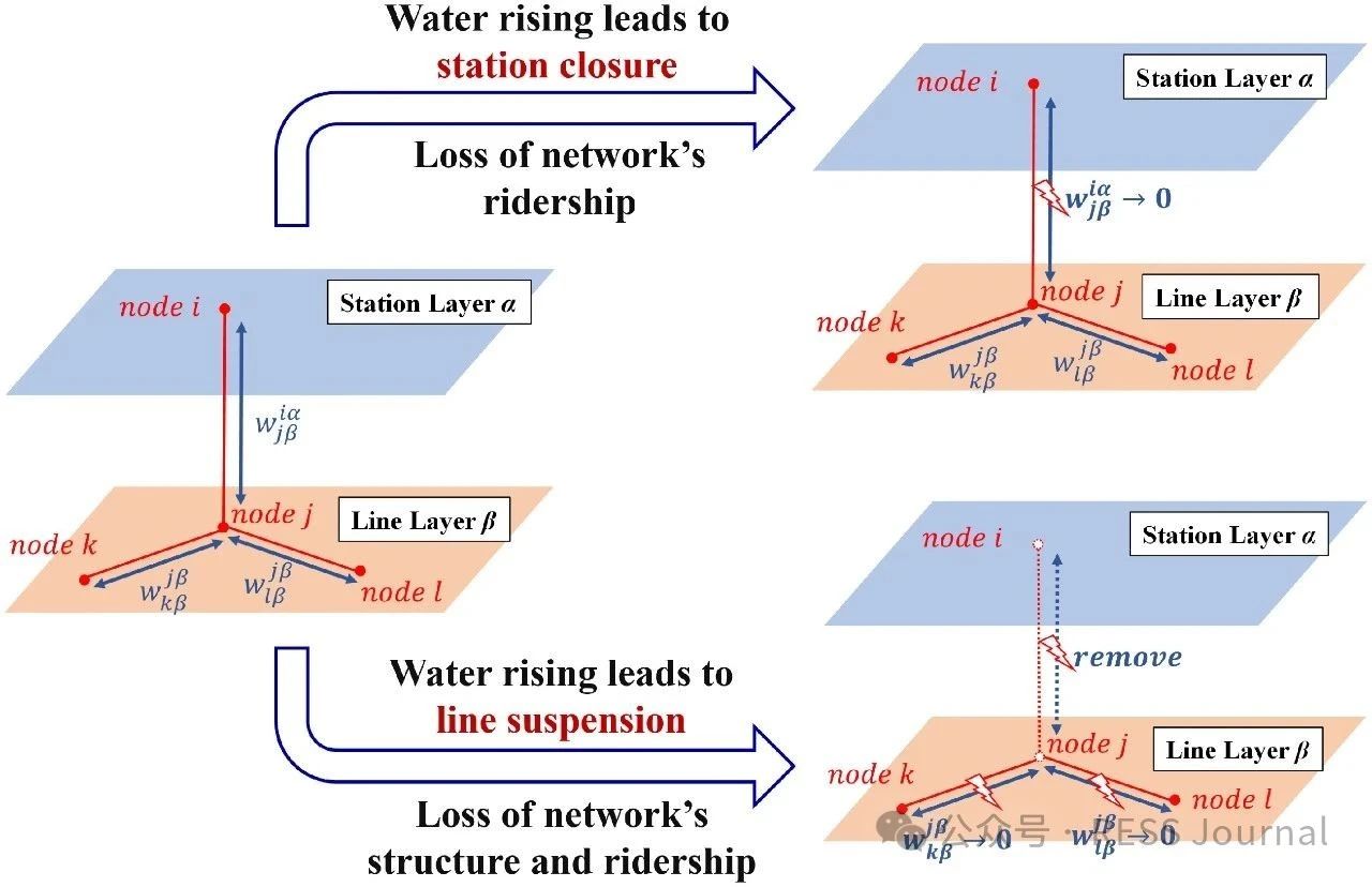
图6. 极端降雨下地铁网络损失过程模型
04 / 原文信息
Abstract
In recent years, a changing climate has induced flood risk as a great threat to the safety and reliability of the metro transit network in mega-cities. A highly networked metro system can lead to a quick spread of this risk, and furthermore, the impact range of single-node accidents of a network is nonlinearly amplified through network connectedness defined by its topology. This study proposes a risk assessment framework integrating extreme rainfall simulation and network loss analysis. The methodology employs the Areal Reduction Factor (ARF) and Soil Conservation Service Curve Number (SCS-CN) to model rainfall-induced flooding, coupled with a multi-layer network-based approach that distinguishes topological interactions between stations and lines. Taking Shanghai metro as an example, this paper highlights its risk follows an exponential distribution to extreme rainfall events, characterized by the finding that nearly 50 % of extreme rainfall events result in <5 % network loss, whereas fewer than 5 % of the events lead to >50 % network loss. When rainfall centers are located in the urban center where metro stations are densely distributed and intricately connected, or when the rainfall intensity and the spatial distribution uncertainty increases, it will pose a greater risk to the metro network.
相关推荐:轨道交通展展位预订 轨道交通展免费报名参观

扫码加入交流群